6.5.1 locate and describe the major river system and discuss the physical setting that supported the rise of this civilization
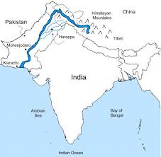
It flows through the regions of Ladakh, Baltistan and Gilgit and runs between the Ladakh Range and the Zaskar Range. It crosses the Himalayas through a 5181 m deep gorge near Attock, lying north of the Nanga Parbat and later takes a bend to the south west direction before entering Pakistan!!!!

The Ganga (Ganges) rises from the Gangotri Glacier in the Garhwal Himalayas at an elevation of some 4100 metres above the sea level under the name of Bhagirathi. This main stream of the river flows through the Himalayas till another two streams – the Mandakini and the Alaknanda – join it at Dev Prayag, the point of confluence. The combined stream is then known as the Ganga. The main tributaries of the Ganga are Yamuna, Ram Ganga, Gomati, Ghaghara, Son, Damodar and Sapt Kosi. The river after traversing a distance of 2525 kms from its source meets the Bay of Bengal at Ganga Sagar in West Bengal.
